


MoonTrajectory.net

MoonTrajectory.net의 설명
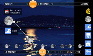
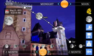
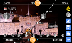
http://MoonTrajectory.netenables you to predict the moon path and its phase, simply looking through your phone.
This is a 100% free app!
Find moonrise and moonset times, not only on the horizon, but also depending on a building or a mountain.
You can even predict where the moon will be... if reflected in water!
Caution: some phones don't handle correctly gyroscopic sensors. Should you notice any innaccurate display, try deactivating gyros into application menu/settings.http://MoonTrajectory.netin the press:
100BestAndroidApps . "Positively awesome."
AppsZoom . "UI is great and features are very interesting."
zAugmentedReality . "Cool app."
If you have a question, if you wish for an improvment or if you have trouble running the application on your phone, please contact sylde.net:http://twitter.com/sylde_nethttp://facebook.com/pages/MoonTrajectorynet/191720237572617contact@sylde.netThe download is 1.3MB big, but the application can be moved on your SD card and would take in that case only 160kB from your internal storage!
Please refer to the bottom of the page for a detailed justification of the different authorizations required by the app.http://MoonTrajectory.netallows you to display the future trajectories of the moon in augmented reality:
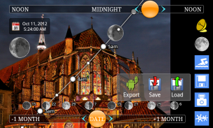
* Look through your phone and see the path of the moon.
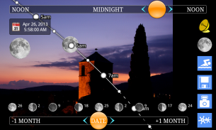
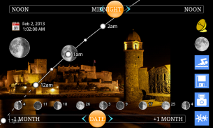
* Find out if the moon will be full or what phase it will be in.
* Plan the moonrise and moonset times, not only on the horizon, but also on a building or a relief.
* Travel in time and see what path the moon will follow in the months to come.
* Take and save photos.
* Check afterwards the different trajectories of the moon for a whole year.
Photography:
* Plan to include the moon in your pictures, whether by day or night.
* Plan when a subject (like a statue for instance) will be aligned with the moon.
* Use the calendar of the moon phases.
* Use the agenda to plan your future pictures.
* This way, you will know when to return to the site to take your picture to the maximum effect.
* Use Google Maps to pinpoint its exact location.
***
Detailed justification of the different authorizations required by the app:
* Modify/delete USB storage contents modify/delete SD card contents
The app enables you to take pictures, so that you can check afterwards on those pictures the different sun or moon paths.
These photos are saved on the SD card. No other data is written or read in the SD card.
These data are deleted in case the app is uninstalled.
* Coarse (network-based) location / fine (GPS) location
The app requires the location of the user to compute the trajectories.
This position needn’t be accurate. That’s why you may use the network as well as the GPS (the first one available will be used).
* Prevent device from sleeping
The app displays live data in augmented reality, superimposed on the video.
The device is thus prevented from sleeping while the app is running.
As soon as the user quits the app, the automatic standby mode is reactivated.
* Full Internet access
The app enables you to check on GoogleMaps where the pictures were taken.
GoogleMaps requires a full internet access to operate.
The internet access is used by both GoogleMaps and the voucher codes system. No personal data is sent.
* Take pictures and videos
The app displays live data in augmented reality, superimposed on the video, and enables you to take pictures and check the different trajectories later/ with a clear head.http://MoonTrajectory.net은단순히 전화를 통해 찾고, 달 경로와 위상을 예측 할 수 있습니다.
이것은 100 % 무료 응용 프로그램입니다!
수평선에뿐만 아니라, 문라이즈 및 월몰 시간을 찾아뿐만 아니라 건물이나 산에 따라 달라집니다.
달이 될 위치도 예측할 수 ... 물에 반영하는 경우!
주의 : 일부 휴대 전화가 제대로 자이로 스코프 센서를 처리하지 않습니다. 당신은 어떤 innaccurate 표시를주의해야, 응용 프로그램 메뉴 / 설정에 자이로를 비활성화하십시오.
언론http://MoonTrajectory.net:
100BestAndroidApps. "긍정적으로 최고."
AppsZoom. "UI는 훌륭한이며, 기능은 매우 흥미 롭다."
zAugmentedReality. "쿨 응용 프로그램."
당신은 질문이있는 경우에는 당신이 improvment 또는 원하는 경우 귀하의 휴대 전화에서 응용 프로그램을 실행하는 데 문제가있는 경우, sylde.net 연락 주시기 바랍니다 :http://twitter.com/sylde_nethttp://facebook.com/pages/MoonTrajectorynet/191720237572617contact@sylde.net다운로드 1.3MB 큰이지만, 응용 프로그램이 SD 카드에 이동 할 수 있으며, 내부 스토리지에서 단지 160KB하는 경우 걸릴 것입니다!
응용 프로그램에 필요한 여러 권한에 대한 자세한 정당화를 위해 페이지 하단을 참조하십시오.http://MoonTrajectory.net는증강 현실에서 달의 미래 궤적을 표시 할 수 있습니다 :
* 귀하의 휴대 전화를 통해보고 달의 경로를 참조하십시오.
달이 가득 차있을 것이다 또는 안으로 될지 위상 경우 * 알아
*뿐만 아니라 수평선에,뿐만 아니라 건물이나 구호, 문라이즈 및 월몰 시간을 계획합니다.
* 시간 여행과 달이 와서 개월 만에 따릅니다 어떤 경로를 참조하십시오.
* 사진을 찍어 저장합니다.
* 전체 년 이후 달의 다른 궤적을 확인합니다.
사진 :
* 하루 밤이든 사진에서 달을 포함 할 계획입니다.
피사체 (예를 들어 동상 같은) 달과 정렬됩니다 * 계획.
* 달 단계 캘린더를 사용합니다.
* 미래의 사진을 계획하는 의제를 사용합니다.
최대의 효과로 사진을 찍을 사이트로 돌아가려면되면이 방법은, 당신은 알게 될 것이다.
*의 정확한 위치를 파악하기 위해 Google지도를 사용합니다.
***
응용 프로그램에 필요한 여러 권한에 대한 자세한 이유 :
* 수정 / 삭제 USB 저장소 콘텐츠 및 SD 카드 콘텐츠 수정 / 삭제
응용 프로그램은 이러한 다른 태양 사진이나 달 경로에 나중에 확인할 수 있도록, 당신은 사진을 찍을 수 있습니다.
이 사진은 SD 카드에 저장됩니다. 다른 데이터를 기록하거나 SD 카드를 읽습니다.
응용 프로그램을 제거 할 경우에이 데이터가 삭제됩니다.
* 거친 (네트워크 기반) 위치 / 고급 (GPS) 위치
응용 프로그램은 궤적을 계산하기 위해 사용자의 위치를 필요로합니다.
이 위치는 정확하지 않아도됩니다. 당신은 네트워크뿐만 아니라 GPS를 (사용 가능한 첫 번째가 사용됩니다)를 사용할 수 있습니다 이유입니다.
* 수면에서 장치를 방지
응용 프로그램은 동영상에 겹쳐 증강 현실에서 라이브 데이터를 표시합니다.
이 장치는 따라서 응용 프로그램이 실행되는 동안 자고 방지합니다.
마자 사용자가 응용 프로그램을 종료로 자동 대기 모드가 활성화됩니다.
* 전체 인터넷
응용 프로그램은 사진을 촬영 한 위치를 구글 맵에서 확인할 수 있습니다.
Google지도는 전체 인터넷 액세스가 작동해야합니다.
인터넷이 Google지도 및 쿠폰 코드 시스템 모두에 의해 사용됩니다. 개인적인 데이터는 전송되지 않습니다.
* 사진과 동영상 찍기
응용 프로그램은 동영상에 겹쳐 증강 현실에서 라이브 데이터를 표시, 당신은 사진을 찍고 나중에 / 맑은 머리 다른 궤적을 확인 할 수 있습니다.


